|
| |
China's Boundary
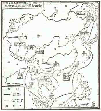
"Chinese Territories Taken by Imperialism in the Old Democratic
Revolutionary Era(1840-1919)" from A Short History of Modern China (first published
in Peking in 1954), a text used in Chinese secondary schools.
Key to Map
(Translation of the information given in boxes on the map)
- The Great Northwest: seized by Imperial Russia under the Treaty of Chuguchak, 1864.
[Parts of present Soviet Kazakhstan, Kirghizia, and Tadzhikstan.]
- Pamirs: secretly divided between England and Russia in 1896.
- Nepal: went to England after "independence" in 1898.
- Sikkim: occupied by England in 1889.
- Bhutan: went to England after "independence" in 1865.
- Assam: given to England by Burma in 1826.
- Burma: became part of the British Empire in 1886.
- Andaman Archipelago: went to England.
- Malaya: occupied by England in 1895.
- Thailand: declared independent" under joint Anglo-French control in 1904.
- Annam: occupied by France in 1885 [covers present North Vietnam, South Vietnam, Laos,
and Cambodia.]
- Taiwan and Peng-hu Archipelago [Pescadores]: relinquished to Japan per the Treaty of
Shimonoseki, 1895.
- Sulu Archipelago: went to England.
- Region where the British crossed the border and committed aggression.
- Ryukyu Archipelago: occupied by Japan in 1879.
- Korea: "independent" in 1895 -annexed by Japan in 1910.
- The Great Northeast: seized by Imperial Russia under the Treaty of Aigun, 1858.
- The Great Northeast: seized by Imperial Russia under the Treaty of Peking, 1860.
- Sakhalin; divided between Russian and Japan.
Translations based on Salisbury's War Between Russia and China.
(China's Boundary Treaties and Frontier Disputes. Luke T. Chang, USA,
1982, p. 217-218. Appendices, MAP 15)
|