 |
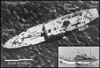
Plate 1: Philippine aerial photo acquired on 1
February 1995 showing a ship that was reportedly located at Mischief Reef. The photograph
has a spatial resolution of .2 meters. Our analysis revealed that this is a Chinese
Yannan-class ship, an armed survey and research vessel. The inset is a reference image of
a Chinese Yannan-class ship from Jane’s Fighting Ships, 1995-1996. The
connected circles show the features in the overhead image that match the reference image.
Because of the overhead view, neither the flag nor the identification marks along the bow
could be seen. (Overhead aerial image courtesy: Agence France-Presse, Reference image
courtesy: Jane’s Information Group) |
 |
Plate 2: Philippine aerial photos acquired in the
spring of 1997. These two armed ships were reportedly photographed in the South China Sea
and identified as Chinese. In the large photo, the flag is not identifiable, but the
ship’s pennant number (‘420’) is legible. The class of the ship is not
known for certain although it may be a variant of Yenlai-class. The inset shows a Chinese
Yannan-class ship with a pennant number of ‘24’ or ‘124’ (see
Yannan-class reference image in Plate 1 inset). (Aerial images courtesy: Agence
France-Presse) |
 |
Plate 3: Aerial photo showing one of four building
clusters that China constructed and occupied. The photo was taken a few months after China
took control of the reef. Many features in the image were identified. The inset shows an
individual standing on a platform scrutinizing the observation aircraft and a second
possibly armed individual positioned behind one of the armor shields along the periphery
of the building cluster. (Courtesy: Agence France-Presse) |
 |
Plate 4: Aerial photo showing another Chinese building
cluster on Mischief Reef. As in Plate 1, many features in the image were identified. In
both clusters, the huts were deliberately built away from the octagonal buildings which
suggests the storage of items that need to be kept away from the living quarters for
safety or hygienic reasons. The inset shows an individual with binoculars watching the
observation aircraft as it flies by. (Courtesy: Agence France-Presse) |
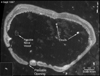 |
Plate 5: 4 September 1997 IRS-1C
satellite image of Mischief Reef. The IRS-1C panchromatic sensor acquired the image at a
six meter ground sample distance. The image was then resampled so that each pixel covers a
5 m x 5 m ground
area. The four reported building clusters could not be identified, but four distinct blips
along the north, south, east, and west perimeter were detected. In addition, a 68±5 meter
long feature inside the lagoon was found that could be a naval vessel. The feature could
not be conclusively identified because its shape was blurred and its shadow was not
visible in the lagoon (see inset). |
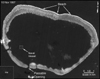 |
Plate 6: 10 November 1997 IRS-1C
satellite image of Mischief Reef. The IRS-1C panchromatic sensor acquired the image at a
six meter ground sample distance. The image was then resampled so that each pixel covers a
5 m x 5 m ground
area. Two blips were detected along the north and east periphery and one naval vessel was
identified. The vessel is 71±5 meters long and it has a distinct, blurred appearance (see
inset). Its class could not be determined, but several ship classes were eliminated from
consideration based on the length measurement. |
 |
Plate 7: This aerial photo was
released by the Philippine Department of National Defense on 10 November 1998. The photo
shows significant construction activity at one of the four Chinese-occupied areas on
Mischief Reef. Working adjacent to octagonal structures that were built in early 1995, the
construction workers can be seen placing metal rods into position for the foundation of a
large, reinforced concrete structure. The inset shows the concrete s |